Posted by: Bonnie Phelps | March 9, 2011

Like a Booth? Want to help? BBQ Mtg Saturday!

The next BBQ planning meeting will be March 12th at 10am in the Community Center.

Would you like to have a booth at the BBQ?

Are you interested in volunteering?

Do you have some fun and new ideas for this years BBQ?

Come along to the meeting and share with us. 

Everyone is welcome and encouraged to come.

PMVFD

Posted by: Bonnie Phelps | March 7, 2011

Big Rock Cabin For Sale

  Come to the mountain top and see what inspired the owners to name their absolutely charming cabin, Big Rock!  Observatory view,  private, peaceful setting on .68 of an acre.  Click to learn more about it then scroll through some photos showing last weekend’s snow, the beautiful knotty pine interior, and of course a big stone fireplace.  Let’s go see!

Bonnie 888 718-5358

Posted by: Bonnie Phelps | March 3, 2011

8 Great Snow Pix

Image taken on Sunday by NASA's Terra satellite, which has an average altitude of 438 miles.  Click to see ‘Heavenly Henshaw Valley’, great satellite photos over the County, and it looks like Scott Kardel’s backyard!

Posted by: Bonnie Phelps | March 3, 2011

Frozen Hot Springs Mtn Lookout via Sailplane!

   From: Brad Eells

Subject: A Frozen Hot Springs Mountain Lookout!

Check out the images of Hot Springs Mountain Lookout sent to me by a sailplane pilot. What a beautiful day to be gliding…

I have a sneaking suspicion that High Point looks pretty much the same…anyone for a snowshoe trip??? No wonder our anemometer is frozen up!

Enjoy!

Brad Eells

Read More…

Posted by: Bonnie Phelps | March 2, 2011

Front Row Seat of County Snow


 Earl and Louise have a front row seat with their spectacular views from their home on Palomar.  Thanks for sharing your photos Louise!

Posted by: Bonnie Phelps | March 2, 2011

Snow Pix from the Weekend

 Several of you have sent some wonderful photos of the snow this past weekend.  Click to see 28 from Rob Hawk.  After you open that link, you can double-click on the first one to enlarge and then click-through to see all.  You’ll also enjoy the comments he posted at the bottom of the pictures.  Rob should be a Realtor!  🙂  Thanks Rob!

Posted by: Bonnie Phelps | March 2, 2011

PMVFD Fire Board Mtg this Saturday

On Behalf Of PMVFD

The next PMVFD Fire Board meeting will be held on Saturday, March 5, 2011, at 10:00 a.m. at the fire station.

 The public is invited to attend. Please  go to www.palomarfire.org to view the agenda

Posted by: Bonnie Phelps | February 27, 2011

Church today on the Mountain

You are invited to join us for a church service today at 10:30 at the Phelps, “Square House” on State Park Road.  Road is plowed and plenty of parking for you. Potluck will follow. 

“This is the day that the Lord has made, we will rejoice and be glad in it”. Psalm 118:24

Posted by: Bonnie Phelps | February 26, 2011

Lotsa Snow in the News

http://www.signonsandiego.com/news/2011/feb/25/arctic-storm-bringing-rain-snow-record-cold/?sciquest

Posted by: Bonnie Phelps | February 26, 2011

Winter Weather Warning

From: PMVFD

Subject: [PMVFD] Winter Weather Warning in effect

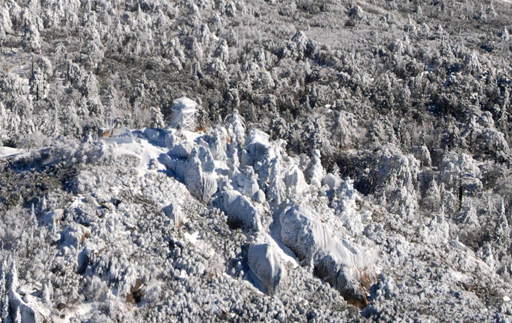
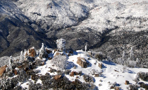
There is a considerable amount of snow accumulated up on Palomar Mountain, with snow continuing to fall. Up to 8 or 9 inches in some areas.

Road conditions are treacherous with visibility at almost zero. Please use caution and stay off the roads if at all possible.
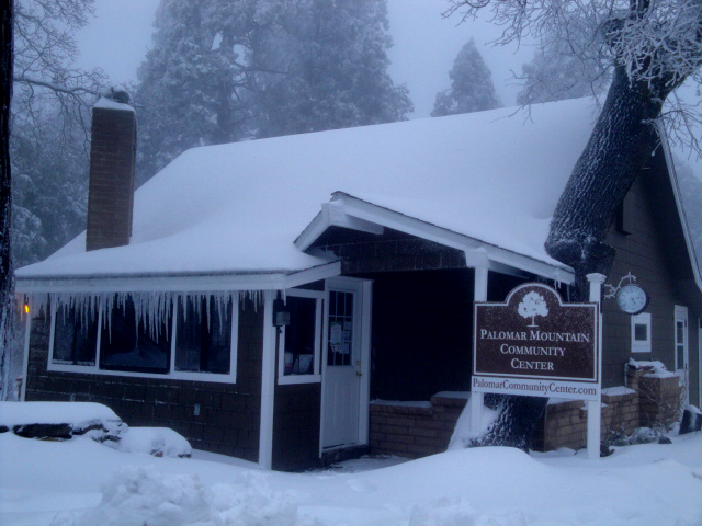
The Community Center has cancelled all scheduled event for today, however it remains OPEN in case of emergency.
http://forecast.weather.gov/MapClick.php?site=sgx&smap=1&textField1=33.32278&textField2=-116.87778
URGENT - WINTER WEATHER MESSAGE
NATIONAL WEATHER SERVICE SAN DIEGO CA
230 AM PST SAT FEB 26 2011
...HEAVY SNOWFALL IN THE MOUNTAINS AND UPPER DESERTS INTO THIS
EVENING...

.A COLD STORM SYSTEM WILL MOVE INLAND ACROSS SOUTHWEST CALIFORNIA
TODAY BRINGING HEAVY SNOW AND STRONG WINDS TO THE MOUNTAINS. SNOW
LEVELS STARTING OUT NEAR 4500 FEET WILL LOWER TO 2000 TO 2500 FEET
THIS EVENING.
...WINTER STORM WARNING REMAINS IN EFFECT UNTIL 3 AM PST SUNDAY
ABOVE 3500 FEET...

A WINTER STORM WARNING ABOVE 3500 FEET REMAINS IN EFFECT UNTIL
3 AM PST SUNDAY.

* ELEVATION: ABOVE 3500 FEET.

* SNOW LEVELS: LOWERING TO 2000 TO 2500 FEET SATURDAY THROUGH
  SATURDAY NIGHT.

* SNOW ACCUMULATIONS: 6 TO 12 INCHES ABOVE 3500 FEET WITH LOCAL
  AMOUNTS OF 12 TO 18 INCHES AT ELEVATIONS ABOVE 5500 FEET.

* TIMING: LATE TONIGHT THROUGH SATURDAY EVENING. GREATEST AMOUNTS
  THIS MORNING WITH SNOW SHOWERS CONTINUING THROUGH TONIGHT.

* LOCATIONS INCLUDE: BOULEVARD...CUYAMACA...DESCANSO...JULIAN...
   MOUNT LAGUNA...PINE VALLEY...RANCHITA

* WINDS: SOUTHWEST 2O TO 30 MPH WITH GUSTS TO 50 MPH.

* VISIBILITY: NEAR ZERO AT TIMES IN HEAVY SNOW...BLOWING SNOW... AND
  DENSE FOG.

* IMPACTS: A WINTER STORM WARNING FOR HEAVY SNOW MEANS SEVERE
  WINTER WEATHER CONDITIONS ARE EXPECTED OR OCCURRING.
  SIGNIFICANT AMOUNTS OF SNOW ARE FORECAST THAT WILL MAKE
  TRAVEL DANGEROUS. SNOWFALL WILL IMPACT TRAVEL ON INTERSTATE
  8 THROUGH THE SAN DIEGO COUNTY MOUNTAINS.

PRECAUTIONARY/PREPAREDNESS ACTIONS...

A WINTER STORM WARNING FOR HEAVY SNOW MEANS SEVERE WINTER WEATHER
CONDITIONS ARE EXPECTED OR OCCURRING. THIS WEATHER COULD BE
DEADLY FOR UNPREPARED CAMPERS OR HIKERS.


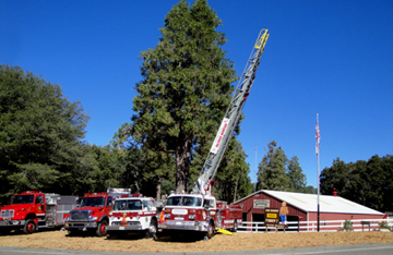
Palomar Mountain Volunteer Fire Department
21610 Crestline Road
Palomar Mountain, CA, 92060

« Newer Posts - Older Posts »

Categories